The Monastery Run Improvement Project (MRIP) is a broad-based effort to remediate abandoned mine drainage (AMD) discharges from Fourmile Run, Monastery Run, and Loyalhanna Creek and thus to restore water quality in the Loyalhanna watershed. The Loyalhanna Creek Mine Drainage Coalition (LCMDC), organized in 1993 composed of more than 50 members, oversaw the design and function of the MRIP during the first 10 years of the project.
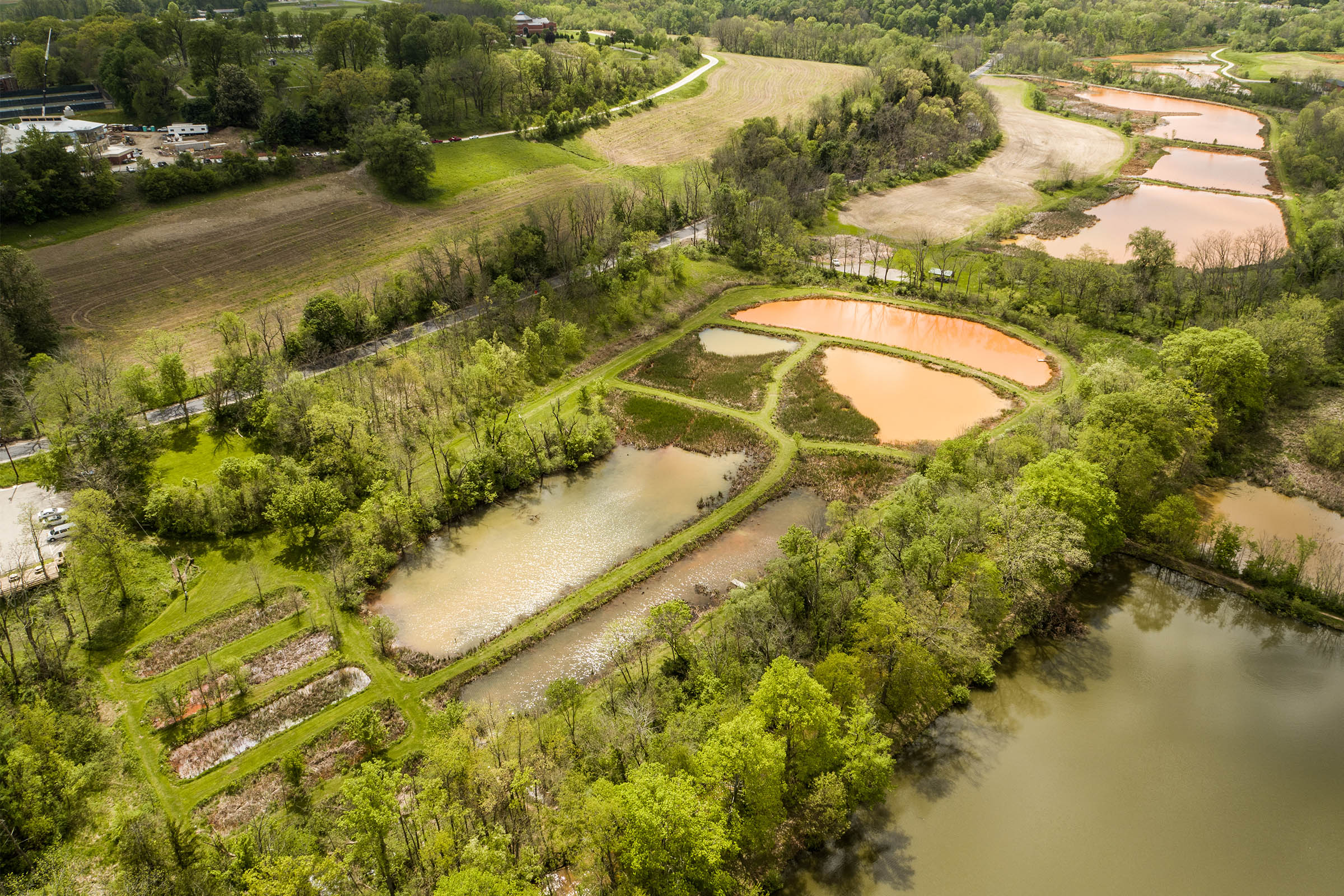
MRIP consists of three passive treatment wetland systems on 20 acres of land owned by Saint Vincent Archabbey and sits adjacent to the historic Saint Vincent Gristmill. Original funding for the MRIP was secured from grants from EPA - Section 319 grant; United States Department of Agriculture Natural Resources Conservation Service (PL-566) and PA-DEP.
The MRIP wetlands have become a uniquely accessible field demonstration site and experiential classroom. Wetland #3 is used to provide hands-on, outdoor educational experiences for undergraduate courses and K-12 programming. The wetlands attract visitors, including government officials, representatives from environmental agencies and local watershed groups, environmental researchers and technical professionals, and community members. The MRIP wetlands also are used by many local citizens for recreation, such as walking, bird watching, cross country skiing, snowshoeing, and geocaching.
Developed in 1997-98, the MRIP consists of three passive wetland systems situated on 20 acres of Saint Vincent Archabbey Property.
The most visible and severe problem identified in the Loyalhanna Watershed was the discharges from abandoned deep mines. Two of the affected streams –Fourmile Run and Monastery Run – were the first major sources of mine drainage into Loyalhanna Creek and were responsible for the physical degradation and elimination of nearly all aquatic life in 0.8 mile of Monastery Run and 1.1 miles of Fourmile Run. Below the mouth of Monastery Run, the aquatic diversity and biomass of Loyalhanna Creek’s mainstream were significantly reduced for the remaining 17.4 miles to its confluence with the Conemaugh River.
When all the wetlands within the MRIP were completed in 1998, the focus then became Education and Outreach. The community had always know about the orange "Sulfur" creeks, but didn't necessarily understand the reason or treatment. The first step was educating the community that the orange ponds were a good thing and their streams would be cleaner, then the next focus was the young children.
Wetland #3 was designed with education in mind. It is very accessible with wide walking paths, and a visible and dramatic color change throughout the wetland demonstrating the process. Wetland #3 has been used to provide hands-on, outdoor educational experiences for undergraduate courses and K-12 programming since 1999.
Since that time, much effort has been put into developing activities and curriculum to teach children and adults about Abandoned Mine Drainage.
Since the installation of the systems, the Loyalhanna Creek has seen significant improvement in water quality and aquatic diversity. Saint Vincent College has maintained the systems by seeking various funds when necessary to rehabilitate different parts of the wetlands.
 |
 |
| Figure 1: Loyalhanna Creek 1997 | Figure 2: Loyalhanna Creek 2002 |
|
WETLAND #1 Wetland #1, located along the north side of Fourmile Run is an 8.5 acre wetland treatment system, designed by the PA Department of Environmental Protection in cooperation with the landowner, Wimmer Corporation. Wetland #1 construction involved excavating an existing wetland area created by ten mine drainage discharges. Wetland #1 consists of four cells with internal dikes that cause the water to flow in a serpentine pattern. Construction was completed November 1998. Flow rates have reached nearly 5 times the amount the wetland was designed to handle during high flow conditions, and almost stops flowing during low flow conditions. In order to provide for better treatment performance, Wetland #1 and Wetland #2 were connected via an inverted siphon that carries the effluent from Wetland #1 under Fourmile Run and discharges it into Wetland #2 in July 1999. The water flows from one cell to the next via a concrete flow control structure. This structure contains removable stop logs to control flow and the top stop log is equipped with a rectangular weir, which allows for the necessary aeration. |
|
| Operation/Maintenance: PA Department of Environmental Protection
Contract Administration: PA Department of Environmental Protection |
Dedicated: October 1998 Construction Cost: 494,423.49 |
|
WETLAND #2 Wetland #2, located along the south side of Four Mile Run, was designed by USDA Natural Resources Conservation Service in cooperation with the landowner, Wimmer Corporation. It was constructed in the summer of 1998. Wetland #2 is a 7.5 acre passive treatment wetland system used to treat abandoned mine drainage which discharges within the existing cattail marsh. Two large cells were built within the existing marsh. In 2001 a new splitter dike was installed in the last cell to create 3 cells and to increase aeration and detention time. The pipeline, which carries water from “The bubbler”, was extended to Wetland #2 in the event of high flows.Special Features of Wetland #2: - A 2,400-foot exterior dike is set back from the stream allowing a riparian buffer zone to remain. |
|
|
Contract Administration: USDA, Natural Resources Conservation Service |
Dedicated: November 12, 1998 Construction Cost: $162,000 |
WETLAND #3
Wetland #3, located behind the Saint Vincent Gristmill, was designed by USDA Natural Resources Conservation Service under a cooperative arrangement with Saint Vincent College. It was constructed in the summer of 1997. Wetland #3 is a 3.11 acre passive treatment wetland system used to treat abandoned mine drainage. It primarily treats water from the artesian discharge which was known as “The Bubbler”. Using the head pressure in the underground mine complex, the mine water from “The Bubbler” is piped upstream 600 feet to a suitable location for treatment. The passive treatment wetland system allows for aeration and detention time sufficient to reduce the iron content from about 90 mg/L to about 2 mg/L.
A Mesocosm (outdoor laboratory) was designed by EES Consultant, Terry Rightnour and consists for four equal-sized cells where field research on mine water treatment may occur. Water can be controlled and monitored to research alternative field treatments. Mine water from a nearby discharge or “The Bubbler” can be used.
Special Features of Wetland #3:
- Maintained an undisturbed 50-foot riparian buffer zone during construction which has been enhanced by additional planting.
- Allowed portions of cattail marsh to remain throughout construction to support biological life.
- A bentonite slurry cut-off trench was installed under the exterior dike to prevent subsurface flow of water between the wetlands and the stream.
- Designed to allow different water depths and flow patterns between cells.
- Hydrogeologic exploration
Natural Resources Conservation Service
Contractor: Stoy Excavating, Somerset, PA
Construction Cost: $220,000
The Screen to Stream project, which was funded by the Pennsylvania (PA) Department of Environmental Protection, aimed to provide local teachers with training, equipment and opportunities to engage students in grades 3-12 with issues affecting watersheds in Southwestern PA including abandoned mine drainage (AMD). The project also sought to provide opportunities to engage young students to explore their local watersheds, identify water quality problems, and ask questions about them.
On this virtual learning lab website, there is a watershed game that teaches students about common impacts on rivers and streams in PA. There are also many learning activities linked to the PA academic standards relating to the environment and ecology in the Nature Interrupted Curriculum. Finally, there are links to other water-related educational materials at the state and national level.
AMD MODULES FOR MIDDLE AND HIGH SCHOOL
Middle School and High School lessons about abandoned mine drainage created by Western Pennsylvania teachers.
